
 Events
Log in
Statistics
We have 477 registered usersThe newest registered user is гераскинс
Our users have posted a total of 48009 messages in 7050 subjects
THAT’S ENTERTAINMENT
CLICK ON ANY OF THESE LINKS TO FIND OUR EXTREME ENTERTAINMENT
UPDATED :
71 WGT TUTORIALS & 32 YOUNG46 TUTORIALS
CLICK HERE TO SEE OVER 100 YOUTUBE VIDEO TUTORIALS . FROM WGTers , WGT & YOUNG46 FORUM UPDATE
TO THE MANY WELCOME GUESTS . THIS FORUM IS NO LONGER A COUNTRY CLUB WEBSITE FOR A WGT COUNTRY CLUB . PLEASE FEEL FREE TO READ THE FORUMS.
THERE ARE MANY TOPICS OF INTEREST . OR NOT . THIS WEBSITE IS AN INFORMATION AND ENTERTAINMENT WEBSITE ONLY .
MUCH OF THE CONTENT IS ARCHIVES OF PURPOSES PAST .
THERE ARE SOME MORE CURRENT TOPICS .
REGISTRATION IS NOT NECESSARY TO READ THROUGHOUT .
REGISTRATION IS EASY AND FREE . THIS IS AN AD FREE WEBSITE . NOTHING IS EVER REQUESTED FROM REGISTERED MEMBERS .
REGISTRATION ENABLES COMMENTING ON TOPICS . POSTING NEW TOPICS . FULL ACCESS TO THE WEBSITE IMAGE HOST . WHICH IS A VERY COMPLETE AND CONVENIENT TOOL .
PLEASE ENJOY .
TIER & AVERAGE REQUIREMENTS
BASIC LEVEL AND AVERAGE REQUIREMENTS , AND SATURATION

WHILE YOUR HERE
WHILE YOUR HERE :
CHECK OUT THE INCREDIBLE PHOTOGRAPHY IN
MY SERIES
THIS USED TO BE THE HOME OF OUR WORLD CLOCK . WHICH CAN NOW BE FOUND IN ITS OWN FORUM ON THE MAIN PAGE ..
THERE ARE MORE WORLD CLOCKS INSIDE HERE .
WORLD CLOCK
FB Like
NAT GEO * The lost continent of Zealandia has been mapped for the first time *
Valley of the Sun Casual Club :: WORDS , FACTS , DATES , GAMES & TRIVIA & HISTORY :: NATIONAL GEOGRAPHIC
Page 1 of 1

 NAT GEO * The lost continent of Zealandia has been mapped for the first time *
![]() by Paul Fri 26 Jan 2024, 1:15 pm
by Paul Fri 26 Jan 2024, 1:15 pm
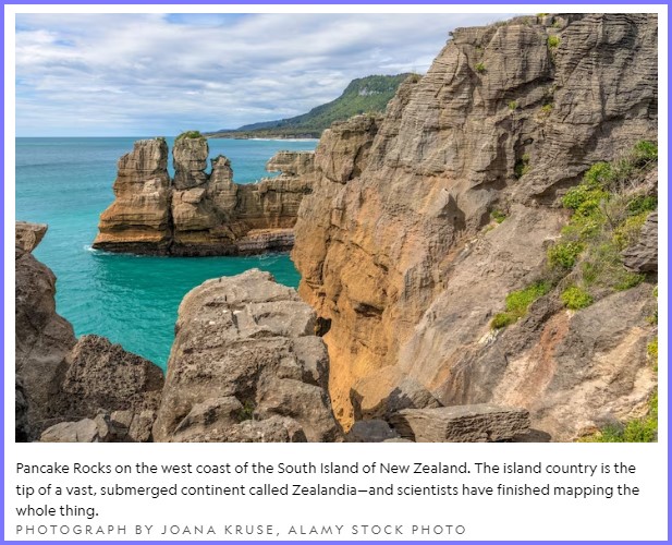
The lost continent of Zealandia has been mapped for the first time
The lost continent of Zealandia has been mapped for the first time
This enormous chunk of submerged continental crust sits between Antarctica and Australia, where it connected the landmasses as part of a supercontinent some 300 million years ago.
BYLIZ KRUESI
PUBLISHED JANUARY 24, 2024
After years of exploration and research, scientists have finished mapping a sunken continent that lurks beneath the South Pacific. This chunk of continental crust, driven to the depths millions of years ago, is known as Zealandia, or by the Indigenous Māori name Te Riu-a-Māui.
By piecing together rock samples with magnetic maps, geologists have revealed the extent of Zealandia, hidden below the ocean surrounding New Zealand. Seven years ago, geologist Nick Mortimer and colleagues revealed the existence of this mostly submerged continent, and in 2021 they mapped the southern portion.
Now in a study published in Tectonics, the scientists have finished mapping this entire continent—all 1.9 million square miles. “We’ve put Zealandia on the map,” says Mortimer, who works for the New Zealand research institution GNS Science.
This new study “shows that New Zealand isn't just a couple of islands,” says geologist James Scott of the University of Otago in New Zealand, who wasn’t involved in the research. “It’s actually an enormous continent that’s almost half the size of Australia—just mostly underwater.”
[size=16]

[size=24]Revealing Zealandia
The world is broken up geologically into continental and oceanic crust.
Most continental crust sits above the oceans, comprising the seven
continents. But the continental shelf extends below the ocean, shown in
lighter colored areas off the coast.
Europe
[/size][/size]
Asia
Africa
Australia
Zealandia
Antarctica
95 percent of Zealandia (Te Riu-a-Māui)
is submerged beneath the ocean. The
"world’s eighth continent" was first
revealed seven years ago.
ZEALANDIA
(TE RIU-A-MĀUI)
Zealandia extent
Continental crust
Oceanic crust
AUS.
As scientists continue to analyze
dredged-up rock samples, the
formation of Zealandia and its place
in the global geologic puzzle
becomes clearer.
Rosemary Wardley, NG Staff.
Sources: Nick Mortimer, GNS Science
Zealandia is a missing piece of the continental crust, says geoscientist Maria Seton of the University of Sydney. It fits like a puzzle piece among the other nearby continents of Antarctica and Australia, allowing geologists to study how Zealandia formed and split from nearby landmasses in geological history.
Now that scientists have charted the boundaries of this hidden chunk of Earth’s crust, they can begin to reveal how and why it formed in the first place—questions that have implications far beyond the continent’s borders.
During a video call, Mortimer holds up a fist-size, splotchy, gray rock—a granite pulled from the team’s 2016 voyage to the northern portion of Zealandia. During the expedition to a site called Fairway Ridge aboard the Australian ship the R/V Investigator, the researchers dredged up hundreds of kilograms of granite and sedimentary samples from the submarine continent.
Such chunks of granite, explains Mortimer, are crushed, sieved, and the remains put into heavy liquids that allow some of the bits to float and others to sink. The bits that sink are then run through a magnet to separate the non-magnetic minerals the researchers are after. The scientists then look at the remaining material under a microscope and pick out—by hand—the zircon crystals.
These are the minerals they’re looking for, because locked within their crystalline structure is a geologic clock. By comparing those crystals with well-studied rocks from New Zealand, says Mortimer, scientists can learn which landmasses formed together. With enough samples, those tiny crystals—each about one-third of a millimeter long—can be used to outline Zealandia’s geology.
The zircons formed when volcanic magma cooled and solidified. Their chemical composition includes uranium, which is a radioactive element, says Rose Turnbull, a geoscientist at GNS Science and co-author of the new study.
“As soon as it’s crystallized, the uranium starts decaying,” says Turnbull. Uranium atoms convert into lead over time, and by measuring the ratio of the two atoms in the zircons, the scientists can determine how long ago they formed.
The magma in the Zealandia granites tended to date to around 100 million years ago—a time that aligns with the breakup of the previous supercontinent.
Imagine poking holes in a cloth and throwing it over a statue. The holes would reveal bits of information about the statue, similar to the samples taken of Zealandia, but they could only tell you so much.
“When we go out on the ships and we collect our samples, they’re pinpricks,” says Seton. “We need to use other methods to try and connect the dots.”
To get a more complete picture, the team used magnetic mapping. With sensors aboard ships, orbiting in space, and stationed on land, researchers can detect magnetic field anomalies. Mortimer and his colleagues looked for the highly magnetic rocks, which tended to be basalts that had solidified from past volcanic activity, and then created maps of these magnetic variations.
Just as the fabric over the statue would give you a general sense of the shape, these magnetic maps provided a sense of Zealandia.
The scientists quickly noticed these magnetic rocks from preciously volcanic regions weren’t randomly arranged, says Mortimer. Instead, they were either parallel or perpendicular to fracture zones deep in the oceanic crust, locations where the continents moved apart.
Those regions, he says, “appear to be related to the stretching of the [supercontinent] Gondwana crust, just before Zealandia and Antarctica and Australia broke up.”
Researchers have learned over the decades that Earth’s continental crust evolves over vast timescales. It follows a general cycle: The land mass is compacted as a supercontinent, then that supercontinent breaks apart into several smaller continents, then the land coalesces together again, and the cycle continues over hundreds of millions of years. Some 250 million years from now, scientists believe, the continents will have merged together again.
Around 300 to 250 million years ago, the supercontinent was Pangea, made up of two smaller parts: the southern chunk, Gondwana, and the northern piece, Laurasia. By 200 million years ago, each of those chunks began moving away from each other.
“When they’re splitting up, what happens is you get new plate boundaries forming, and you get two pieces of continent pulling themselves apart, stretching the continental crust, making that thinner,” says Seton.
A rift within Gondwana where current-day Zealandia met Antarctica and Australia was pulling apart around 100 million years ago, unleashing a spur of volcanic activity. That heated the crust, which was stretched out “like pizza dough,” says Mortimer, until around 60 million years ago.
Then the area started to cool down, and what is now Zealandia became denser and sank into the ocean, almost totally submerged by about 25 million years ago, says Mortimer. Today, only five percent of the total continent pokes above water—the islands of New Zealand, New Caledonia, and a few islands of Australia.
The northern portion of Zealandia is still connected to Australia, while the southern portion is strongly attached to Antarctica. To learn more about these junctures, and the geological history they can reveal, will require more samples and additional analyses. The researchers, says Seton, have already dredged more than 50 samples during a 2019 investigation and are still combing through the data.
“If you look at [Zealandia] now, it’s kind of like a blurry photograph, and with more sampling, that becomes more clear,” says Scott. “Finally the picture is unraveled, but it still remains, you know, under a kilometer of water.”

The lost continent of Zealandia has been mapped for the first time
This enormous chunk of submerged continental crust sits between Antarctica and Australia, where it connected the landmasses as part of a supercontinent some 300 million years ago.
BYLIZ KRUESI
PUBLISHED JANUARY 24, 2024
After years of exploration and research, scientists have finished mapping a sunken continent that lurks beneath the South Pacific. This chunk of continental crust, driven to the depths millions of years ago, is known as Zealandia, or by the Indigenous Māori name Te Riu-a-Māui.
By piecing together rock samples with magnetic maps, geologists have revealed the extent of Zealandia, hidden below the ocean surrounding New Zealand. Seven years ago, geologist Nick Mortimer and colleagues revealed the existence of this mostly submerged continent, and in 2021 they mapped the southern portion.
Now in a study published in Tectonics, the scientists have finished mapping this entire continent—all 1.9 million square miles. “We’ve put Zealandia on the map,” says Mortimer, who works for the New Zealand research institution GNS Science.
This new study “shows that New Zealand isn't just a couple of islands,” says geologist James Scott of the University of Otago in New Zealand, who wasn’t involved in the research. “It’s actually an enormous continent that’s almost half the size of Australia—just mostly underwater.”
[size=16]
[size=24]Revealing Zealandia
The world is broken up geologically into continental and oceanic crust.
Most continental crust sits above the oceans, comprising the seven
continents. But the continental shelf extends below the ocean, shown in
lighter colored areas off the coast.
Europe
[/size][/size]
North
America
Asia
Africa
South
America
Australia
Zealandia
Antarctica
95 percent of Zealandia (Te Riu-a-Māui)
is submerged beneath the ocean. The
"world’s eighth continent" was first
revealed seven years ago.
ZEALANDIA
(TE RIU-A-MĀUI)
New
Caledonia
Zealandia extent
Continental crust
Oceanic crust
SOUTH
PACIFIC
OCEAN
AUS.
As scientists continue to analyze
dredged-up rock samples, the
formation of Zealandia and its place
in the global geologic puzzle
becomes clearer.
NEW
ZEALAND
Tasman
sea
Rosemary Wardley, NG Staff.
Sources: Nick Mortimer, GNS Science
Zealandia is a missing piece of the continental crust, says geoscientist Maria Seton of the University of Sydney. It fits like a puzzle piece among the other nearby continents of Antarctica and Australia, allowing geologists to study how Zealandia formed and split from nearby landmasses in geological history.
Now that scientists have charted the boundaries of this hidden chunk of Earth’s crust, they can begin to reveal how and why it formed in the first place—questions that have implications far beyond the continent’s borders.
Rocks from below
During a video call, Mortimer holds up a fist-size, splotchy, gray rock—a granite pulled from the team’s 2016 voyage to the northern portion of Zealandia. During the expedition to a site called Fairway Ridge aboard the Australian ship the R/V Investigator, the researchers dredged up hundreds of kilograms of granite and sedimentary samples from the submarine continent.
Such chunks of granite, explains Mortimer, are crushed, sieved, and the remains put into heavy liquids that allow some of the bits to float and others to sink. The bits that sink are then run through a magnet to separate the non-magnetic minerals the researchers are after. The scientists then look at the remaining material under a microscope and pick out—by hand—the zircon crystals.
These are the minerals they’re looking for, because locked within their crystalline structure is a geologic clock. By comparing those crystals with well-studied rocks from New Zealand, says Mortimer, scientists can learn which landmasses formed together. With enough samples, those tiny crystals—each about one-third of a millimeter long—can be used to outline Zealandia’s geology.
The zircons formed when volcanic magma cooled and solidified. Their chemical composition includes uranium, which is a radioactive element, says Rose Turnbull, a geoscientist at GNS Science and co-author of the new study.
“As soon as it’s crystallized, the uranium starts decaying,” says Turnbull. Uranium atoms convert into lead over time, and by measuring the ratio of the two atoms in the zircons, the scientists can determine how long ago they formed.
The magma in the Zealandia granites tended to date to around 100 million years ago—a time that aligns with the breakup of the previous supercontinent.
Connecting the dots
Imagine poking holes in a cloth and throwing it over a statue. The holes would reveal bits of information about the statue, similar to the samples taken of Zealandia, but they could only tell you so much.
“When we go out on the ships and we collect our samples, they’re pinpricks,” says Seton. “We need to use other methods to try and connect the dots.”
To get a more complete picture, the team used magnetic mapping. With sensors aboard ships, orbiting in space, and stationed on land, researchers can detect magnetic field anomalies. Mortimer and his colleagues looked for the highly magnetic rocks, which tended to be basalts that had solidified from past volcanic activity, and then created maps of these magnetic variations.
Just as the fabric over the statue would give you a general sense of the shape, these magnetic maps provided a sense of Zealandia.
The scientists quickly noticed these magnetic rocks from preciously volcanic regions weren’t randomly arranged, says Mortimer. Instead, they were either parallel or perpendicular to fracture zones deep in the oceanic crust, locations where the continents moved apart.
Those regions, he says, “appear to be related to the stretching of the [supercontinent] Gondwana crust, just before Zealandia and Antarctica and Australia broke up.”
The continental puzzle
Researchers have learned over the decades that Earth’s continental crust evolves over vast timescales. It follows a general cycle: The land mass is compacted as a supercontinent, then that supercontinent breaks apart into several smaller continents, then the land coalesces together again, and the cycle continues over hundreds of millions of years. Some 250 million years from now, scientists believe, the continents will have merged together again.
Around 300 to 250 million years ago, the supercontinent was Pangea, made up of two smaller parts: the southern chunk, Gondwana, and the northern piece, Laurasia. By 200 million years ago, each of those chunks began moving away from each other.
“When they’re splitting up, what happens is you get new plate boundaries forming, and you get two pieces of continent pulling themselves apart, stretching the continental crust, making that thinner,” says Seton.
A rift within Gondwana where current-day Zealandia met Antarctica and Australia was pulling apart around 100 million years ago, unleashing a spur of volcanic activity. That heated the crust, which was stretched out “like pizza dough,” says Mortimer, until around 60 million years ago.
Then the area started to cool down, and what is now Zealandia became denser and sank into the ocean, almost totally submerged by about 25 million years ago, says Mortimer. Today, only five percent of the total continent pokes above water—the islands of New Zealand, New Caledonia, and a few islands of Australia.
The northern portion of Zealandia is still connected to Australia, while the southern portion is strongly attached to Antarctica. To learn more about these junctures, and the geological history they can reveal, will require more samples and additional analyses. The researchers, says Seton, have already dredged more than 50 samples during a 2019 investigation and are still combing through the data.
“If you look at [Zealandia] now, it’s kind of like a blurry photograph, and with more sampling, that becomes more clear,” says Scott. “Finally the picture is unraveled, but it still remains, you know, under a kilometer of water.”

Paul- Admin

- Posts : 45383
Join date : 2013-05-06 -


» VANISHING AVATAR AGAIN
» LOST OR STOLEN PHONE HELP
» CRAIGSWAN'S LOST & SCATTERED ARCHIVES
» REIMBURSEMENTS FOR COINS LOST BY FALSE FORFEITS
» LOST YANCY WGT TAPES - "100" (titled before) - From app. 2012
» LOST OR STOLEN PHONE HELP
» CRAIGSWAN'S LOST & SCATTERED ARCHIVES
» REIMBURSEMENTS FOR COINS LOST BY FALSE FORFEITS
» LOST YANCY WGT TAPES - "100" (titled before) - From app. 2012
Valley of the Sun Casual Club :: WORDS , FACTS , DATES , GAMES & TRIVIA & HISTORY :: NATIONAL GEOGRAPHIC
Page 1 of 1
Permissions in this forum:
You cannot reply to topics in this forum


» INTRO TO WORD SMARTS
» PINTEREST ICONIC COMIX
» HISTORY FACTS * Gold wasn't always the top Olympic medal *
» Word Genius Word of the day * occlude *
» JULY NATIONAL CELEBRATION DAYS JULY 26 2024
» QUIZ TREAT QUIZ *Which mammal has the most powerful bite? *
» QUIZ TREAT ANSWER PAGE
» NAT GEO * The 2024 Olympics will likely be the hottest ever *
» NAT GEO * Sharks found with cocaine in their systems *
» WISE TRIVIA QUIZ *What was the first song ever played on the radio? *
» WISE TRIVIA ANSWER PAGE
» E.S.Etaski * Sister Seekers Book 10 now available everywhere! *
» WORD DAILY Word of the Day: * literatim *
» JULY NATIONAL CELEBRATION DAYS JULY 25 2024